Abouts Us

DigimyLand is a promising product. Help Client to digitize their land and properties records as well as Geo map the same. Using the latest remote piloted aerial mapping technology to Geo map the land and properties information. Designed in such a way that a Client can access each and every details related to its land and properties assets in complete respect. Help to identify the anomaly between actual land and properties area as per documents versus area as per geo mapping. App is accessible on Android, iOS & Web app also.

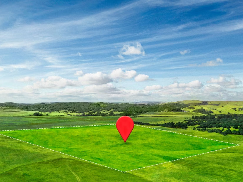
Digital land can include a wide range of information, including topography, land use, property boundaries, zoning information, and more. This data is often used by governments, urban planners, and other organizations to make informed decisions about land use and development. One of the key benefits of digital land is that it allows for more accurate and efficient analysis of land and property. With digital data, it is easier to create maps and visualizations, measure distances and elevations, and identify patterns and trends. This can be useful in a variety of fields, including urban planning, environmental management, and natural resource exploration.

Logo

An overview of a Land Record Management System (Digimyland Product)

Land records are essential for managing land ownership and property rights. They can also be used for taxation, planning, and development. Traditionally, land records have been managed on paper or in a siloed system. This can make it difficult to access and share information, and it can also be prone to errors.

(1) Accessibility: Land records can be accessed from anywhere with an internet connection.

(2)Collaboration: Stakeholders can share information and collaborate on projects more easily..

(3)Accuracy: Data can be entered and stored in a centralized location, which can help to reduce errors.

(4)Security: Data can be encrypted and stored in a secure environment.

Challenges to Keep Land Record

Lack of difitization

Land records are often stored in paper form, which makes them difficult to access and use. This can lead to delays in processing land transactions, as well as the risk of fraud and errors.

Inaccuracy

Land records are often inaccurate, due to human error or outdated information. This can lead to disputes over land ownership or use, as well as the risk of financial losses.

Inaccessibility

Land records are often inaccessible to the public, which can make it difficult for people to track their property rights or to resolve disputes.

Lack of transparency

Land record management systems are often opaque, which makes it difficult for people to understand how land is being managed. This can lead to a lack of trust in the system and the risk of corruption.

Lack of resources

Land record management systems often lack the resources they need to operate effectively. This can include things like funding, staff, and technology.

Cost

Traditional methods of geo fencing, and geo mapping can be expensive. This is because they require the use of physical markers, as well as the expertise of surveyors and engineers.

Scalability

Traditional methods of geo fencing, and geo mapping are not scalable to large areas. This is because they require a large number of physical markers, which can be expensive and time-consuming to install.

Influencers interference

Land record management systems are often subject to political interference. This can lead to corruption and the manipulation of land records for personal gain.

Land Record Management System Solutions

There are several ways to address the challenges, including:

Logo

1. Digitizing land records

This can make them more accessible and easier to use, which can help to reduce fraud and errors

2. Modernizing land record management systems

This can help to improve efficiency and transparency.

3. Making land records more accessible to the management

This can help people to track their property rights and to resolve disputes.

4. Improving transparency in land record management systems

This can help to build trust in the system and reduce the risk of corruption.

By addressing these challenges, users can improve the efficiency and effectiveness of their land record management, which can have a positive impact on the economy.

Benefits of Land Record Management

Land records are official documents that record the ownership, use, and boundaries of land. They are an essential part of land administration
and management, and they play a vital role in many aspects, including:

Property Rights

Land records help to ensure that property rights are clear and secure. This is important for both individuals and businesses, as it allows them to use their land as collateral for loans, to sell or transfer it, or to develop it.

Taxation

Land records are used to assess property taxes. This is important for governments, as it provides a reliable source of revenue.

Planning And Development

Land records are used to plan and develop land. This includes things like zoning, infrastructure development, and environmental protection.

Dispute Resolution

Land records can be used to resolve disputes over land ownership or use. This can help to prevent costly and time-consuming litigation.

Promoting Economic Development

Land records can help to attract investment and promote economic development. This is because they provide investors with confidence that their property rights are secure.

Reducing Poverty

Land records can help to reduce poverty by providing people with access to credit and other financial services. This is because land can be used as collateral for loans, which can help people to start businesses or to improve their homes.

Logo

Overview of Digimyland Solution

Welcome to Digimyland, where we revolutionize land record management using the power of BI on cloud with our cutting-edge technology and value-added services. Say goodbye to cumbersome paperwork and long waits - our digital platform simplifies the process, providing instant access to accurate land records. From property ownership details to transaction history, we've got you covered. Experience a seamless and efficient way of managing land records with Digimyland.

Digimyland is unlocking the potential of the cloud, bringing together all the land records in one place, accessible at your fingertips. This is the Land Record Depository, a game-changer for the industry. Digimyland provides real-time updates. No more waiting weeks for paper documents to be processed. With the power of the cloud, you get instant access to land records, ensuring you always have the most up-to-date information

Benefits and Features of Digimyland

Digimyland is a cloud-based land records management system that offers a variety of features, including:

  • Data Storage

    Land records can be stored in a centralized location in the cloud.

  • Dashboards And Reports

    Dashboards and reports can be created to share information with stakeholders.

  • Collaboration

    Stakeholders can share information and collaborate on projects using the cloud-based system's collaboration features.

  • Geomapping

    Digimyland allows users to store and manage land records, as well as create geofences. Geofences are virtual boundaries that can be used to track the movement of people or assets.

  • Property Valuation

    Digimyland offers a property valuation tool that can be used to estimate the value of land. This tool uses a variety of factors to determine the value of land, such as location, size, and zoning.

  • Vastu Services

    Digimyland provides Vastu consultancy to its users based on the principles of vastu shastra, an ancient Indian system of